Skip to product information
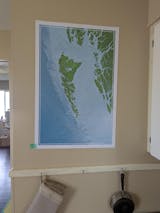
Map of Haida Gwaii - www.cdedwards.com
1/5

Map of Haida Gwaii

$129.00 CAD

An ocean-focused wall map that helps you tell better stories and plan better adventures.

20x30 map professionally printed using archival-quality materials and processes.

This Haida Gwaii map balances the grit of the working mariner with the spirit of the ocean adventurer:

  • Colours that capture the rainforest and slate blue seas
  • Ocean-first design with features that matter to waterpeople
  • Labeled like a nautical chart
  • Highlights good provisioning towns
  • Includes water depth shading
  • Paper maps show you the whole story all at once
  • Made for storytelling and adventure planning

Some waters test everything you've got. Some places don't forgive mistakes. This map of the Haida Gwaii archipelago, including Gwaii Haanas, honors the remote edges of BC's north west coast, where adventure calls the bold.

Map Purpose

This map is for dreaming and story-telling. It is not a nautical chart and is not intended for navigation.

Materials

All maps are printed with giclée techniques using fade resistant, archival inks on 240gsm, satin photo paper with a resin coating. The result is a crisp white base with vibrant colours.

All maps are rolled paper prints with a ~0.78" (2cm) white border that makes them ready to mat and frame.

Dimensions: 30x20 inches (77x51 cm) measured to the outside edge of paper.

Print Colour

Every digital screen displays colour differently so please be aware that the actual item may appear to be slightly different in color than what you see on your computer or phone screen.

Canada Post Strike
  • USA: No issues. Printed in USA. Free standard shipping. No strike delays. No tariffs. No customs. No duties.
  • All Canadian orders: Printed in CAD. Free standard shipping. No tariffs. No customs. No duties.
  • Canada Urban Shipping: No issues. Areas with courier access ship free via UPS during strike.
  • Canada Remote + PoBox Shipping: Delays: Due to rotating strike existing and new orders will arrive as Canada Post service resumes.

Why You'll Love it

Intentional Design

Every detail is chosen with a mariner’s eye: clear lines, balanced design, no clutter. Only the things that you need to tell your story.

Quality Materials

Printed on archival, eco-conscious paper using Giclée printing and with plastic‑free packaging. Built to last and align with mindful values.

Customer Care

I'm just a one person, putting their art out into the world. I care that you get a good product and love your map.

Frequently Asked Questions

Can't find what you're looking for?
Send me a message.

These maps are for anyone who likes the ocean: sailors, surfers, fisherman, paddlers, divers, coastal hikers; people who hike up that hill for a sunset over the water, and anyone who loves a good tidepool. PSST...they also make a great gift :)
People who see the map can walk up to it and start asking questions and you start telling stories you forgot you had. You dream bigger. You plan BIGGER. You remember that being on the water matters to you so you do it more.
These maps are from an ocean perspective. The labels are similar to what's one a marine chart: bays, inlets, channels, seas. The towns are good stops for provisions or places to start an adventure. The colours feel like the place feels. It's from a mariners perspective. It's a map for waterpeople made by a waterperson.
An analogue, paper map is pure magic. It let's you see everything all at once. It lets you understand the big picture and easily switch to the details. And! Unlike a phone, everyone can look at the same thing at the same time, which makes for much better stories.
Nope. A nautical chart is a very specific, standardized, tool for safe navigation. A chart helps you keep your boat floating and lets you find your way at sea.These maps are not for navigation. They are for decoration, general trip planning , dreaming, and storytelling,
When an order comes in your map goes into the print queue within 6 hours (gives us some time to correct any address issues). The maps are off the printer and in the mail within 2 to 5 days. Then it's usually 3-10 days for standard shipping.
I ship to Canada and the United States. In the future, I will ship internationally, but if you are desperate for a map send me a message and I can do a custom order for you.
If you order from Canada, your map is printed and shipped in Canada. If you order from the US, your map is printed and shipped in the US. This means no surprise fees for anyone.
My mission at the CDEdwards Map Store is to provide maps that are works of art that you will enjoy for years to come. I understand the uncertainties associated with online shopping and I want to make the process as simple as possible.30 days, no questions asked. See the Returns and Exchanges policy for more details.
Yup. My boat is a Kelly Peterson 44 called Whisky Jack II. Because I live on a boat, when you place an order, your map is printed by my professional photography and fine art print partners.
Aerial view of a forested coastline next to the ocean in British Columbia, Canada

Why I made this map

For a long time Haida Gwaii was the last frontier of my sailing goals. I remember being so proud of myself the first time I crossed the fabled Hecate Strait! Little did I know that I had barely touched the edge of what this archipelago has to offer a waterperson.

It's not easy. The east side is crazy shallow, the west side is craggy and deep. The forecasts are shifty. The charts are thin. Help is far away. But if you work for it, if you bring your skills up, it's worth the struggle and stress. It's got some of the biggest beaches I've ever seen. The longest narrows I've ever taken my boat through. The steepest, wildest west coast you could possibly imagine. Crazy beach combing. All the wildlife. And a lot of rain. It's so worth it.

You may also like